Antarctic Weather Control!
Ah, Infowars. You manage to be the premiere right-wing conspiracy theory group and also the best parody of right-wing conspiracy theorists at the same time.
I don’t remember how I stumbled across this video. I think it was on Tuesday, give or take, but I’m not sure about when either. I tried to embed but WordPress wasn’t having that, so you’ll have to follow the link if you want to watch it. Which is fine, they have a transcript there which is, frankly, easier to work with.
Let’s spend a paragraph or two describing the video.
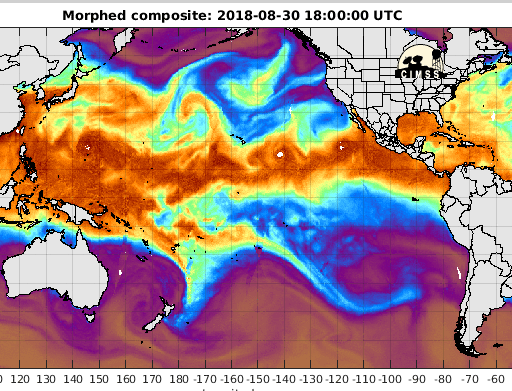
Owen Shroyer is our host, and he begins by challenging us to call him crazy, call him a conspiracy theorist. Then he shows us an animated map of total precipitable water from August 9th. He narrates how there are two hurricanes forming in the Pacific, then a wave or energy beam emanates from Antarctica and suddenly the budding storms split and dissipate. Then we’re treated to a similar map from the same source around August 22, (he says “yesterday”, it was posted on the 23rd, and the world is large and has time zones) and a similar effect is described.
Then Shroyer and his guest, Professor Darrell Hamamoto, speculate wildly that since John Kerry went to Antarctica in November of 2016, maybe he’s connected to these events, and that there might be, and I’m just going to quote from the transcript here, “there might be a direct line that connects that facility down in Antarctica to the Kalorama neighborhood of Washington D.C., where the Obama Foundation is housed”.
Okay Owen, you’re a conspiracy theorist.
So what are we seeing, and why am I so confident that it’s nothing? I’m not seeing hurricanes splitting as Shroyer describes, but there’s clearly a sort of ripple effect that seems to move in a straight line from somewhere off the South edge of the map around 70° West Longitude.
I managed to track down the website they got that image from using specialized, highly technical research skills and difficult to access resources (searched “total precipitable water” on Google) and spent five minutes looking at the different maps available. Two things jumped out at me: First that there’s a big message suggesting you use the new and improved site instead, which is actually visible in the Infowars video. Second, that all of those maps have little glitches and distortions in them.
It’s probably not too surprising that those glitches and distortions get worse near the end of the animation. I’m assuming that the data is gathered from many sources, probably both satellite and ground stations, and assembled by machine. So the most recent data is going to be the patchiest, least refined. It also makes sense that the new tool has significantly less errors in it than the old one. Finally, it also makes sense that people who want to spin a story out of nothing would use the older, glitchier site.
Is that all we’re seeing in those waves or rays or whatever they are? Just graphical artifacts caused by machine processing? I’m going with “yes”, in fact I’m feeling very confident that we aren’t seeing anything that was in the air, but only in the data and only in the display of that data, and here’s why: It’s a straight line.
Here’s a snippet from the page itself. Notice that all the coordinate lines have right angle intersections, forming a grid? That tells us that this map is some sort of cylindrical projection. See, the Earth is a globe, while maps are generally flat. This causes various kinds of distortion, depending on what kind of projection your map uses.
Say you were to fly a plane in a straight course from, say, Machu Picchu Base on King George Island, which is about 62°S, 58.5°W, all the way across the equator to Honolulu, Hawaii which is around 21.3°N, 158°W. Now we draw a line showing that exact course on a map made with the Mercator projection. That line will be curved. I spent some time on Google Maps using the distance measuring tool to look at how lines curve around the globe, and I suggest you do too because it’s not only relevant but very relaxing (and also because I couldn’t get a good screenshot).
Okay, but the wave/beam/ray was wide and happened very fast, maybe we just don’t see that curve? That’s unlikely, but fair, I suppose. Though it doesn’t really help. The wavbearay looks to be around 400 or 500 miles wide, well over 5,000 miles long, is active for three or four hours, and apparently didn’t produce any other effects that a world scrutinized by satellites and covered in pocket cameras was able to record.
Now I don’t know what’s going on here, I’m not claiming to have an answer, I’m just saying, the graphical artifact is a WAY simpler explanation.
But that’s not why Owen’s a conspiracy theorist. Saying, “I think that looks like a ray” doesn’t make anyone a conspiracy theorist. No, that’s what happens next. And it’s amazingly weird.
Here’s a quote from the transcript, Owen Shroyer is speaking here:
I’m just showing you what’s going on and asking if this has anything to do with the hurricane or perhaps even maybe something going on with the South China Sea with China trying to take it over. So Professor Hamamoto, you’ve now seen what I’m talking about, you’re well versed on these issues, and again China and Russia have both been fully public now as far as their weather weapons are concerned, or their ability to control the weather is concerned, they’re not so open about it in America now.
Yeah. I like how he just casually drops in that China and Russia can control the weather. Everyone knows that. I imagine them petulantly sending rain to spoil each other’s picnics. And where’s that stuff about the South China Sea coming from? I guess that’s probably part of an ongoing conversation, that would make sense to regular viewers, but it sure took me by surprise! I tried to get a screen shot of a map showing the South China Sea and the apparent origin of the wavberay, but Google Maps is not feeling very screenshot-friendly today.
If you were expecting Prof. Hamamoto to be the voice of reason, well, have you forgotten that this came from Infowars? The good professor thinks that it’s relevant and worth discussing that John Kerry “made a quick trip to Antarctica not too long ago, did he not?”
I was able to find the New York Times article that they put on screen about John Kerry’s November 2016 visit, which actually discusses the election and the politics of climate science much more than the visit itself. The article provides a location, Scott Base, which is a New Zealand research station right next to the American McMurdo Station. Both of these are located on Ross Island, which is due South of New Zealand.
Let’s be clear here, the John Kerry connection is literally that he was on the continent two years ago. That’s it.
Not even the same general area, either. If we’re certain that this must be an American weather control ray, it would presumably come from Palmer Station on Anvers Island, the only active, permanent American base in the general area the thing appears to come from, and 2,300 miles away from the place Kerry visited.

Google Maps finally gives me a screenshot I can use. It’s not until I upload it that I notice I used McMurdo instead of Scott Base, naturally. They’re right next door to each other, so I’m not fixing it.
I think it’s interesting that these two guys talk about Antarctica like it’s a small place with a single American presence. There are more than 40 permanent Antarctic stations active right now, and another 45 or so that are summer-only. The United States accounts for five of those stations, 3 permanent and 2 summer. Shroyer and Hamamoto speak of “that facility” as though that’s all they need to say.
Another interesting thing they do is sort of notice a thing and then act like that’s relevant. It’s like a weird free association game. This thing happened in August 2018, it looks like it was connected to Antarctica, John Kerry was in Antarctica in November 2016, John Kerry was Obama’s Secretary of State, could there be a connection between Antarctica and Barack Obama?!
I’m just kidding, it would be nuts to connect Obama to this just out of thin air, wouldn’t it?
HAMAMOTO: You know there might be a direct line that connects that facility down in Antarctica to the Kalorama neighborhood of Washington D.C., where the Obama Foundation is housed
God damn it, Darrell.
What amazes me is that he names the specific neighborhood of D.C. but doesn’t say which Antarctic facility he’s talking about. Uneven specificity is the Devil’s playground, Professor. I’m old enough that “a direct line” sounds like an actual, physical wire to me, but even if we assume that he’s just talking about a dedicated communication channel to the much nearer Palmer Station, that’s going to involve satellites.
Why does he think this? Because Obama is somehow still the bogeyman, I guess. Still pulling the strings behind the scenes, still coming for your guns, still using secret Antarctic weather control beams to protect Americans from hurricanes.
I noticed that they kept saying it was “suspicious”, that the FBI should be questioning Kerry about what exactly he was up to on the other side of that continent from their mystery beam, yet the thing they say it actually did would have been preventing a potential disaster. Obama just isn’t very good at being evil, I suppose.
Ultimately, this post was more about the journey than the destination. I’ve been wanting to write more, and I saw this wacky thing and had opinions on it. I learned a few things in my minimal research, for example that there is an international agreement to keep Antarctica free of military operations. I’m also pretty sure I did more research than they did. In the end, this post was a lot of words about a thing that’s obvious nonsense on its face, but it was fun to write.
One thing’s for sure, though. Owen Shroyer is a conspiracy theorist.
Posted on September 2, 2018, in Daily Post and tagged Antarctica, Barack Obama, conspiracy theories, Darrell Hamamoto, Evil Obama using secret technology to protect Hawaii?, Infowars, John Kerry, Owen Shroyer, weather control devices. Bookmark the permalink. 1 Comment.


this was fun to read, leo! i’m glad it caught your imagination and poked you in just the right way.